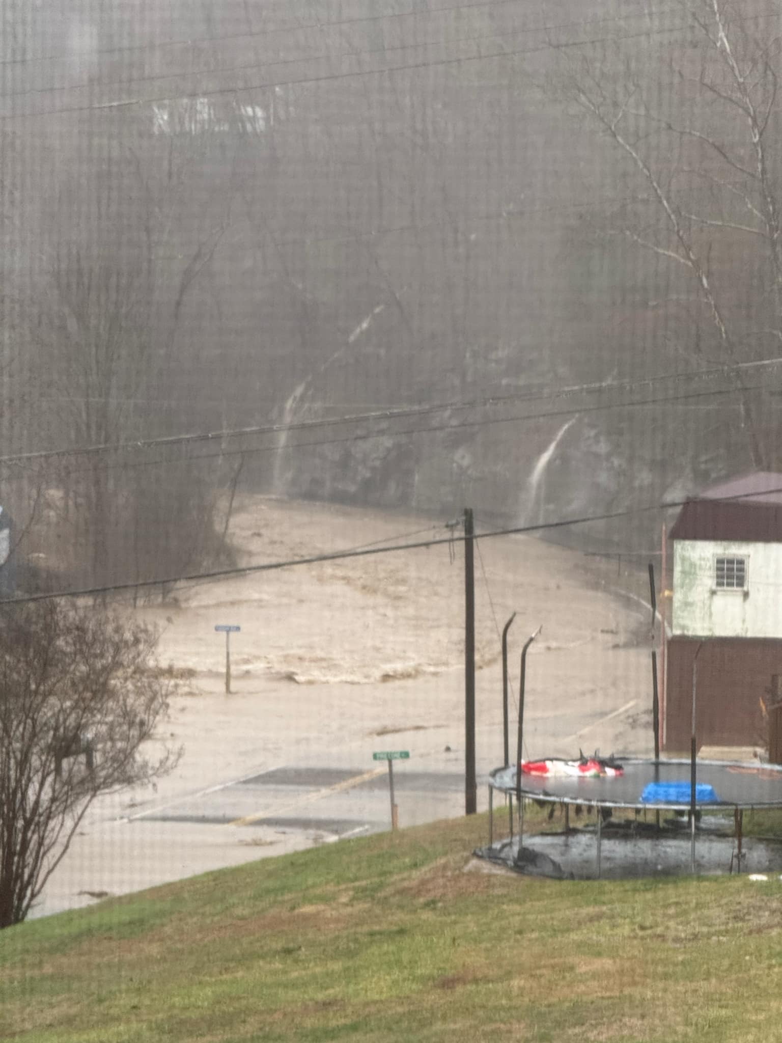
HURLEY, Va. – Deadly flash flooding swept across parts of four states on Saturday as a potent storm system produced a myriad of threats across the eastern half of the nation.Numerous reports of impassable roads dotted the map in western Tennessee, southern Kentucky and near the West Virginia-Virginia border where rainfall reports climbed to over 5-8 inches during the first half of the weekend with more rain still to come.The threat was significant enough to trigger precautionary evacuations along some streams and rivers in the Tennessee Valley and forced the opening of some shelters.A nursing home in Red Boiling Springs, Tennessee, near the state border with Kentucky, was evacuated out of an abundance of caution and water rescues were reported to be ongoing around Hurley, Virginia.”Our street department has been out all week this week placing sandbags and barricades in areas that are prone to flooding because they’re low-lying or near creeks or waterways. So, they’ve done that and done it very well. And then we’ve just been responding as the water continues to rise, and the rain continues to fall,” said Clarksville Mayor Joe Pitts.The Clay County, Kentucky Coroner’s Office reported that a 73-year-old man from the Blue Grass State was found dead in the Horse Creek area of Clay County after apparently getting knocked off his feet by rushing water while exiting his vehicle along Highway 80.At this time, the coroner’s office said it is treating the event as an accidental drowning because of the heavy weather.In Corbin, Kentucky, flood waters carried a truck off a road and into nearby ditch, according to a storm report from the National Weather Service office in Jackson, Kentucky.Near Lewisburg, Kentucky, swift water rescue teams were needed to rescue a driver who became trapped in swift waters of the swollen Mud River, the NWS reported. Another water rescue was needed to the west in the town of Murray.Kentucky Governor Andy Beshear issued a state of emergency for the commonwealth and warned that 3-5 inches of rainfall would be problematic for some areas. “We want everyone to be careful,” Beshear stated. “The amount of rain coming down will make it hard to drive, and flash flooding, especially across our roads, can create dangerous conditions. And remember, don’t drive through standing water, it can have a current, and it is incredibly dangerous.”NOAA’s Weather Prediction Center issued their most dire level 4 flash flood threat rating of “extreme” for parts of northwestern Tennessee and southwestern Kentucky.Catastrophic flooding was reported to be ongoing in Hurley, Virginia near the West Virginia-Virginia border, with a Flash Flood Emergency being issued by the NWS in Charleston, West Virginia.”We’re going to see a number of rockslides, a number of landslides, a number of mudslides and debris flows in eastern Kentucky due to the tremendous about of rain that we’re going to pick up the rest of (Saturday),” says FOX Weather Meteorologist Michael Estime.Flooding even stretched into southwestern Virginia, where Gov. Glenn Youngkin says he’s deployed the National Guard among other first responders to the area.”There’s so much moisture available and it’s going to continue to get pumped in from the south throughout the day,” FOX Weather Meteorologist Ari Sarsalari said. “This is the real problem here – 1 to 2 inch per hour rain rates. That’s a that’s an extreme rate of rain. So it’s going to be falling so heavily, the creeks and streams start to get overloaded. And then all of a sudden, before you know it, you’ve got catastrophic flooding going on, which is definitely a possibility today.”WHY RARE ‘HIGH RISK’ FLOOD DAYS NEED TO BE TAKEN SERIOUSLYHigh risks are only issued on about 4% of days, but this risk category accounts for 39% of flood-related fatalities and 83% of flood-related damage in the continental U.S., according to research by WPC meteorologists. About half of such alerts result in at least one death.A Level 3 out of 4 risk for flash flooding expands farther out into the Ohio and Tennessee Valleys as potential exists for numerous flash floods, some of which could be significant. Flood Watches have been issued that extend over 900 miles from Arkansas to Pennsylvania. About 11 states are included under these.


