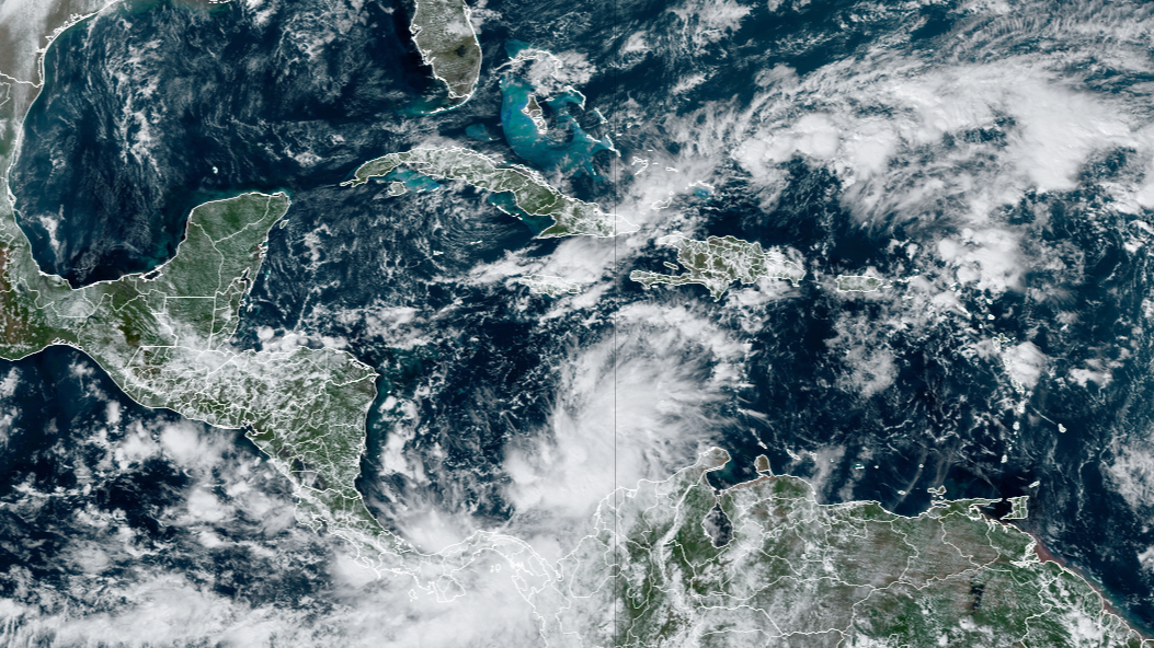
As of Sunday at 4 p.m. ET, Invest 97L has become Potential Tropical Cyclone Eighteen. Continuous coverage of Potential Tropical Cyclone Eighteen has moved here.A budding weather disturbance in the Caribbean Sea is increasingly likely to develop into a tropical depression or tropical storm within the next couple of days, according to the National Hurricane Center (NHC).The system, dubbed Invest 97L by the NHC, was producing showers and thunderstorms that were beginning to show signs of organization over the south-central Caribbean Sea as of Sunday afternoon.Gradual development is expected in the days ahead, and a tropical depression or tropical storm is likely to form as the system moves northward toward Jamaica, the Cayman Islands and Cuba, according to the NHC. An Air Force Hurricane Hunter aircraft was actively investigating Invest 97L on Sunday afternoon.WHAT IS AN INVEST DURING HURRICANE SEASON?”Interests in those locations should monitor the progress of this system as Tropical Storm Watches or Warnings could be required later today or tonight,” the NHC said in its latest outlook.With a subtropical system in the northern Atlantic earning the name Patty on Saturday, should this Caribbean disturbance reach tropical storm strength, the next name on the 2024 Atlantic list is Rafael.”There is disagreement among the computer forecast models on how strong likely-Rafael will be when it moves into the Gulf of Mexico. The predictions range from a low-end tropical storm to a Category 1 hurricane,” FOX Weather Hurricane Specialist Bryan Norcross said. “Flooding rain is possible over the Caribbean islands west of Puerto Rico. The rich tropical moisture is forecast to spread from south to north over the Florida Peninsula starting Tuesday.”Norcross says once the system is in the Gulf, the forecast gets fuzzy with weaker steering currents that add uncertainty to the forecast.”Once likely-Rafael gets to the Gulf, the steering currents may weaken, meaning the system will move more slowly,” Norcross said. “Reasonable tracks for the end of the week range from west toward Mexico or Texas to north toward the Florida Panhandle.”But the storm may still find hostile atmospheric conditions if it attempts to approach the U.S., with a lot of dry air in the Gulf of Mexico and an unfavorable upper-level wind pattern.”Hostile upper-level winds have been screaming across the northern Gulf and the Southeast, and unless the long-range computer forecasts are completely wrong, they will continue,” Norcross added. “All of the long-range projections weaken the system significantly before it reaches the Gulf Coast.”Norcross cautioned that forecasts for slow-moving systems are always extra iffy, and this one hasn’t even formed yet, so it’s important for residents along the U.S. Gulf Coast to stay informed throughout the week ahead.BRYAN NORCROSS: TROPICAL DISTURBANCE IN THE CARIBBEAN LIKELY TO BECOME TROPICAL STORM RAFAEL THIS WEEKThe NHC is also monitoring an area of low pressure near the southeastern Bahamas, but this system has a low chance of developing over the next couple of days.”The disorganized disturbance passing over the Turks and Caicos Islands and the southeastern Bahamas is unlikely to amount to anything,” Norcross said. “Its moisture is forecast to be absorbed by the developing Caribbean system.”The National Hurricane Center is giving this system a low chance of becoming a tropical depression over the next couple of days. Even if that should happen, however, it wouldn’t change the expected weather, Norcross said.HOW TO WATCH FOX WEATHERAccording to the NHC, an area of disturbed weather is expected to develop near the northern Leeward Islands around midweek.Some slow development of this system is possible thereafter as it moves generally westward over the southwestern Atlantic Ocean.Right now, the NHC says it has a low chance of development over the next seven days.In the North Atlantic, Subtropical Storm Patty was moving away from the Azores on Sunday. It’s expected to become a post-tropical cyclone by Sunday night, according to the NHC.The Azores could pick up an additional 1-2 inches of rain through early Monday. In addition, Patty could bring life-threatening surf and rip currents to the archipelago.The storm’s remnants could eventually reach Portugal and western Spain early this week.
/
November 3, 2024
Invest 97L in Caribbean likely to develop into Tropical Storm Rafael


