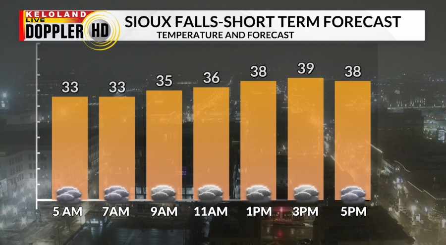
SIOUX FALLS, S.D. (KELO) – Good morning KELOLAND! On the day after Christmas, we are starting the day with areas of fog once again in eastern KELOLAND. Temperatures have been rising into the 30s and much of the frost is melting in the Sioux Falls area.
The latest fog advisories as of 7am are displayed on the map below.
Temperatures will slowly climb close to 40 in Sioux Falls later today. The clouds will be hard to move, so we’ll keep mostly cloudy skies in the forecast.
On Futurecast, the cloud line will hold tough in much of eastern KELOLAND, but keep an eye on the western edge just west of Sioux Falls. Temperatures will still be much warmer in western SD, where lower 50s are expected today. For tonight, expect a chance of light rain or light snow in the Black Hills as a weak disturbance tracks across western SD. Also, more light showers will try to develop in far eastern KELOLAND starting tonight into tomorrow. Much of the rain will slide east of KELOLAND.
You can see the path of that rain into Minnesota and Iowa Friday into early Saturday. Much of KELOLAND will enter into a mild weekend with a blend of sun and clouds and highs in the 40s. Then, another storm system will move into the region Sunday night and Monday. This should bring a mix of rain and snow chances to KELOLAND.
How much snow are we expecting? It’s a little too early to get specific, but a general northwest to southeast swath of snow is expected to fall on Monday across northern Nebraska into southern South Dakota. Many of these areas have seen very little snow all winter. Stay tuned and we’ll have more information later today and into the weekend.
In the meantime, we have a high probability of mild temperatures for the rest of 2024.
Here are the details of the forecast.
