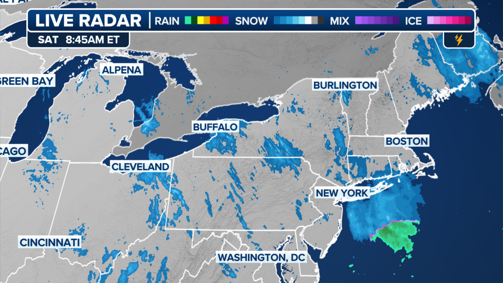
ALBANY, N.Y. — The weather headlines have been filled recently with the massive lake-effect snowstorms that buried the Great Lakes area in feet of snow, and then just in the last day, the first measurable snow of the year for much of the I-95 corridor.But while skies were clearing Saturday morning and the region appeared to head toward calmer weather for the weekend, Mother Nature had a few hidden tricks up her sleeve.”At first glance, it seems like a pretty boring radar picture across the Northeast (Saturday) morning,” said FOX Weather Senior Meteorologist Greg Diamond. “But look closer and there are actually a few really cool things happening!”He first illustrated a thin, but intense band of snow falling just to the east of Cleveland. This was the infamous lake-effect snow in action.Or should we say “lakes-effect” snow?”This is due to extra moisture being drawn from not only Lake Erie, but Lake Huron too,” Diamond said.Another arctic air mass was sweeping out of Canada, over the Great Lakes and into the Northeast on Saturday. As that cold air passes over the relatively warm lakes, warmth and moisture from the water are picked up and transferred into the lowest portion of the Earth’s atmosphere.WHAT MAKES LAKE EFFECT SNOW?This rising air condenses into clouds, which can grow into narrow bands that are capable of producing snowfall rates on the order of 2 to 3 inches per hour or more, according to the National Weather Service.But it wasn’t just “Great” Lake-effect snow falling Saturday. Lake-effect snow was also occurring downwind of the Finger Lakes in central New York, bringing lingering snow to Ithaca and Binghamton, spreading into northeastern Pennsylvania.And the process also brought snow in the Burlington, Vermont area with arctic winds coming off Lake Champlain.But it wasn’t all lake-generated snow. Albany, New York was getting snow from a process Diamond described as the “Mohawk-Hudson Convergence.””This is when winds are channeled east along the Mohawk Valley and south through the Hudson Valley,” Diamond said. “They combine near Albany, and lift caused by their collision leads to the development of snow.”Snow will eventually fade across the Northeast as the drier arctic air mass takes over the region with the coldest temperatures so far this season.
/
December 21, 2024
Sneaky snow phenomena in Northeast hidden inside ‘boring’ Doppler Radar image
