SIOUX FALLS, SD (KELO) — Our timer for the number of hours below zero officially began on Sunday night at 10 pm in Sioux Falls. We’ll see how long this lasts as we go through the next several days.
As of 3 pm CST Monday
Bitter cold will stick around through at least Wednesday across KELOLAND, with many locations struggling to get above zero by the Wednesday outlook. By Thursday, we have a much better chance at getting above zero…but until then it is going to be dangerously cold at times.
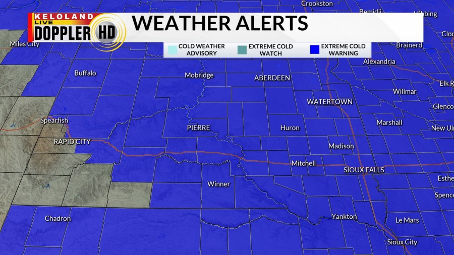
Extreme cold warnings are in effect beginning tonight and lasting through midday on Tuesday if you’re south of US Highway 212. If you’re along or north of the highway, that extreme cold warning goes until midday on Wednesday. Wind chill values may drop as low as -40 to -45 degrees, which would cause frostbite to occur in as little as ten minutes. A cold weather advisory is also in effect for southeastern portions of KELOLAND until 9 pm CST tonight.
By the time we reach the weekend, some big changes are on the way. We have a noticeable warm-up that takes over and sends temperatures from the freezer into a pretty solid thaw across KELOLAND. Temperatures return to the 40s to the east, with 50s and even some 60s possible by the start of next week.
As we head into the start of March, odds for above average temperatures are pretty heavily favored.
In terms of active weather, we do still have some snow in southwestern KELOLAND to watch…not just into the evening but also for Tuesday.
Winter weather advisories remain in effect until 11 am MST Tuesday for southwestern South Dakota, including the Rapid City area. Please be mindful of slippery roads if you must head out.
After Tuesday, moisture will be rather tough to come by across the board. We’ll stay dry into the weekend and the start of next week.
Here’s a look at your extended forecast: