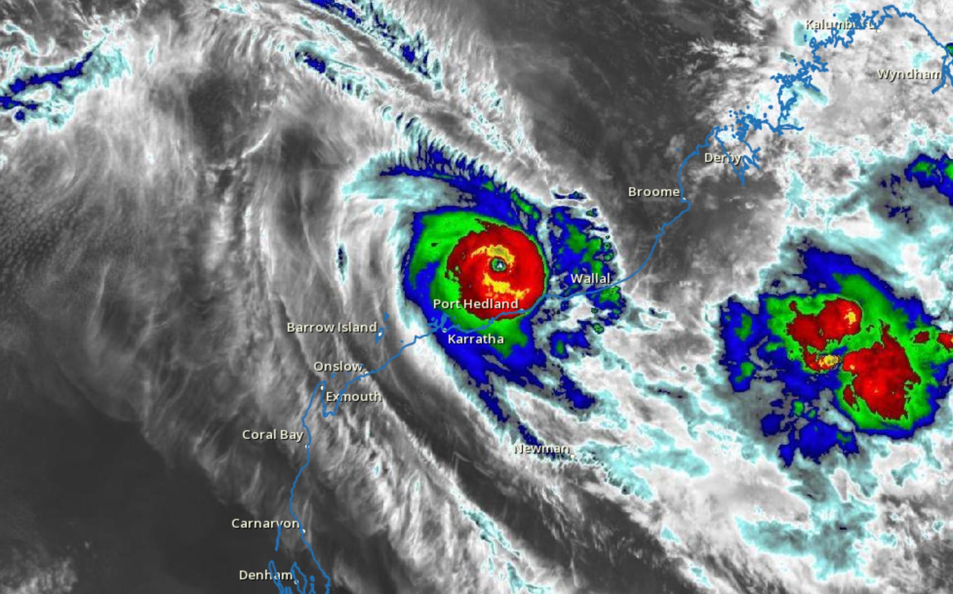
PORT HEDLAND, Australia – Residents in Western Australia are bracing for Tropical Cyclone Zelia’s impacts after the storm rapidly strengthened into a destructive Category 5 storm ahead of its expected landfall on the Pilbara coast.Australia’s Bureau of Meteorology reported that the Category 5 cyclone was on a trajectory to impact the Pilbara region, with Port Hedland, a major mining and resource hub, directly in its path.Zelia’s development resembled that of a rapidly strengthening hurricane, with lightning surrounding a pinhole eye.Within 24 hours, the storm exploded from a Category 3 to a Category 5 cyclone with sustained winds up to 127 mph (205 kph) and gusts up to 177 mph (285 kph), according to the Australian Bureau of Meteorology.Upper-level winds were considered conducive to development, and water temperatures were estimated to be a blistering 86-88 degrees Fahrenheit.Additionally, the FOX Forecast Center said the jet stream’s position was helping to ventilate the cyclone before its arrival during the late workweek.In addition to damaging winds, severe flooding is also a major concern for the region, as tropical moisture is expected to persist for days in the western part of the country.DEMISE OF AUSTRALIA’S LARGE KANGAROOS LIKELY NOT CAUSED BY CLIMATE CHANGE, STUDY SUGGESTSTropical Cyclone Warnings are in place from Wallal Downs to Dampier and extending inland to Marble Bar and Millstream.According to the Bureau of Meteorology, destructive winds are expected to arrive on the Pilbara coast Friday morning and increase Friday afternoon as Zelia nears the coast. The system’s eye will likely cross the coast between De Grey and Karratha later on Friday. Port Hedland, located about 1,000 miles north of Perth, is among the communities most at risk, and preparations were underway with flight disruptions and school closures ahead of the worst of the weather.Some parts of the region are still recovering from Tropical Cyclone Ilsa, a Category 5 storm that hit western areas in 2023.Australia’s cyclone season runs from November to April, which is during the Southern Hemisphere’s spring and summer months.According to Australia’s climate services, the country typically tracks around a dozen cyclones annually, with four or five that make a direct landfall. Cyclone activity tends to spike during La Niña climate events, with twice as many cyclones impacting the region when compared to El Niño years.AUSTRALIA DECLARES EL NINO OVER IN TROPICAL PACIFICWhile there is no established link between Australia’s cyclone activity and the Atlantic hurricane season, both regions’ cyclone patterns are influenced by the broader El Niño-Southern Oscillation, or what is often referred to as the ENSO.The state of the ENSO is expected to remain either in a weak La Niña or neutral status through most of the remaining months of the year, which will impact cyclone activity elsewhere around the globe when development begins to percolate in around three to six months.

